Jane Jacobs on Neighborhoods

Google image on 5/4/16 – Jane Jacobs 100th birthday.

Continuing on with my discussion of neighborhoods, it seems apt to talk about how Jane Jacob defines neighborhoods in her book The Death and Life of Great American Cities. She is often given perfunctory citations in criminology articles for the idea that mixed zoned neighborhoods (those with both residential and commercial zoning all together) increase “eyes on the street” and thus can reduce crime. I will write another post more fully about informal social control and how her ideas fit in, but here I want to focus on her conception of neighborhoods.

She asks the question, what do neighborhoods accomplish – and from this attempts to define what is a neighborhood. Thus she feels a neighborhood can only be defined in terms of having actual political capital to use for its constituents – and so a neighborhood is any region in which can be organized enough to act as an independent polity and campaign against the larger government in which it is nested. This is quite different from the current conception of neighborhoods in most social sciences – in which we assume neighborhoods exist, calculate their effects on behavior, and then tautologically say they exist when we find they do affect behavior.

Based on her polity idea Jacob’s defines three levels of possible neighborhoods:

  • your street
  • the greater area of persons – around 100,000
  • the entire city

This again is quite different than most of current social sciences. Census tracts and block groups are larger swaths than just one block. In very dense cities like NYC, census block groups are often the square defined by streets on either side, so they split apart people across the street from one another. Census tracts intentionally are made to contain around 8,000 people. For a counter-example criminologist, Ralph Taylor does think streets are neighborhood units. A hearsay paraphrase of his I recently heard was “looking out your front door, all that matters is how far you can see down the street in either direction”.

I think Jacob’s guesstimate of 100,000 may be partly biased from only thinking about giant megapolises. Albany itself has only around 100,000 residents – so it is either streets or the whole city per her definition. Although I can’t argue much about smaller areas having little to no political capital to accomplish specific goals.

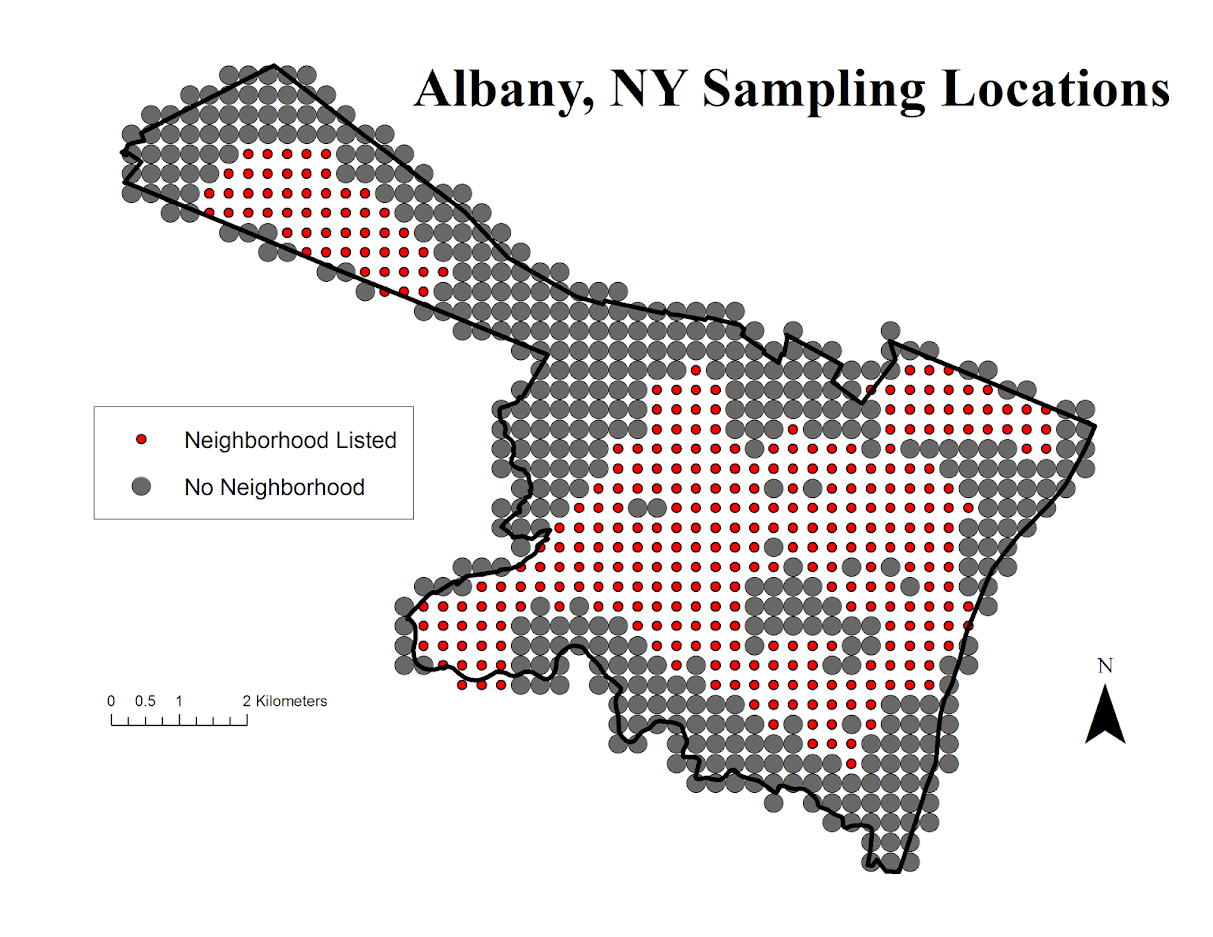
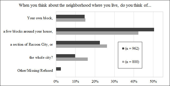
In some of the surveys I have participated in they have asked the question about how you define your neighborhood. Here are the responses for two different samples (from the same city at two different time points) for an example:

I think the current approach – that neighborhoods are defined by their coefficients on the right hand side of regression models is untenable in the end – based on ideas that are derivatives of the work in my dissertation. Mainly that discrete neighborhood boundaries are a fiction of social scientists.

Neighborhoods in Albany according to Google

One of the most vexing aspects of spatial analysis in the social sciences in the concept of neighborhoods. There is a large literature on neighborhood effects in criminology, but no one can really define a neighborhood. For analysis they are most often assumed to approximately conform to census areas (like tracts or blocks). Sometimes there are obvious physical features that divide neighborhoods (most often a major roadway), but more often boundaries are fuzzy.

I’ve worked on several surveys (at the Finn Institute) in which we ask people what neighborhood they live in as well as the nearest intersection to their home. Even where there is a clear border, often people say the “wrong” neighborhood, especially near the borders. IIRC, when I calculated the wrongness for one survey in Syracuse we did it was only around 60% of the time the respondents stated they lived the right neighborhood. I do scare quotes around “wrong” because it is obviously arbitrary where people draw the boundaries, so more people saying the wrong neighborhood is indicative of the borders being misaligned than the respondents being wrong.

For this reason I like the Google maps approach in which they just place a label at the approximate center of noteworthy neighborhoods. I emulated this for a recent background map I made for a paper in Albany. (Maps can be opened in a separate tab to see a larger image.)

As background I did not grow up in Albany, but I’ve lived and worked in the Capital District since I came up to Albany for grad school – since 2008. Considering this and the fact that I make maps of Albany on a regular basis is my defense I have a reasonable background to make such judgements.

When looking at Google’s reverse geocoding API the other day I noticed they returned a neighborhood field in the response. So I created a regular sampling grid over Albany to see what they return. First, lets see my grid and where Google actually decides some neighborhood exists. Large grey circles are null, and small red circles some neighborhood label was returned. I have no idea where Google culls such neighborhood labels from.

See my python code at the end of the post to see how I extracted this info. given an input lat-lng. In the reverse geo api they return multiple addresses – but I only examine the first returned address and look for a neighborhood. (So I could have missed some neighborhoods this way – it would take more investigation.)

Given the input fishnet I then dissolved the neighborhood labels into areas. Google has quite a few more specific neighborhoods than me.

I’ve never really made much of a distinction between West Hill and Arbor Hill – although the split is clearly at Henry Johnson. Also I tend to view Pine Hill as the triangle between Western and Central before the State campus – but Google and others seem to disagree with me. What I call the Pinebush Google calls the Dunes. Dunes is appropriate, because it actually has sand dunes, but I can’t recall anyone referring to it as that. Trees are pretty hard to come by in Arbor Hill though, so don’t be misled. Also kill is Dutch for creek, so you don’t have to worry that Normanskill is such a bad place (even if your name is Norman).

For a third opinion, see albany.com

You can see more clearly in this map how Pine Hill’s area goes south of Madison. Google maps has a fun feature showing related maps, and so they show a related map on someones take for where law students should or should not get an apartment. In that map you can see that south of Madison is affectionately referred to as the student ghetto. That comports with my opinion as well, although I did not think putting student ghetto was appropriate for my basemap for a journal article!

People can’t seem to help but shade Arbor Hill in red. Which sometimes may be innocent – if red is the first color used in defaults (as Arbor Hill will be the first neighborhood in an alphabetic list). But presumably the law student making the apartment suggestions map should know better.

In short, it would be convenient for me (as a researcher) if everyone could agree with what a neighborhood is and where its borders are, but that is not reality.


Here is the function in Python to grab the neighborhood via the google reverse geocoding API. Here if it returns anything it grabs the first address returned and searches for the neighborhood in the json. If it does not find a neighborhood it returns None.

#Reverse geocoding and looking up neighborhoods
import urllib, json

def GoogRevGeo(lat,lng,api=""):
  base = r"https://maps.googleapis.com/maps/api/geocode/json?"
  GeoUrl = base + "latlng=" + str(lat) + "," + str(lng) + "&key=" + api
  response = urllib.urlopen(GeoUrl)
  jsonRaw = response.read()
  jsonData = json.loads(jsonRaw)
  neigh = None
  if jsonData['status'] == 'OK':
    for i in jsonData['results'][0]['address_components']:
      if i['types'][0] == 'neighborhood':
        neigh = i['long_name']
        break
  return neigh